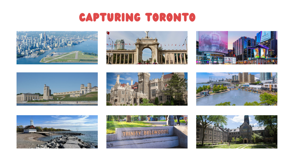
Capturing Toronto: 9 Picture-Perfect Spots to Make Lasting Memories
- Billy Bishop Airport
- Dundas Square
- Princes’ Gate
- Casa Loma
- R. C. Harris Water Treatment Plant
- Harbourfront
- Woodbine Beach
- University of Toronto
- Trinity Bellwoods
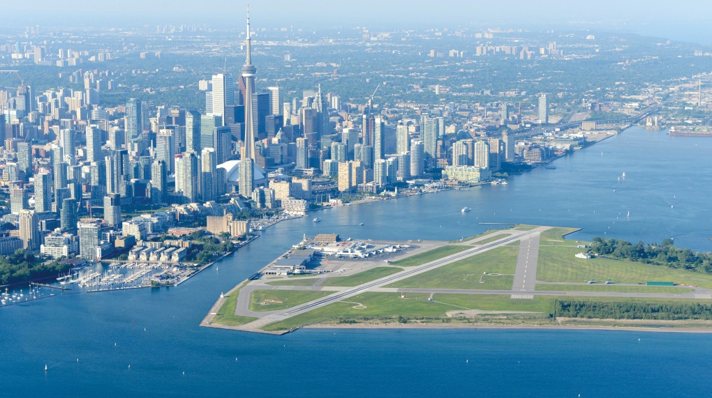
1. Billy Bishop Airport:
1.1 History-
Billy Bishop Toronto City Airport (IATA CODE- YTZ) is a regional airport located on the Toronto Islands in Toronto, Ontario, Canada. The airport’s name honors Billy Bishop, the Canadian World War 1 Flying Ace and World War 2 Air Marshal. It is used by civil aviation, air ambulance and regional airlines using turbo-prop planes. In 2022, it was ranked Canada’s 9th busiest airport.
Visit Billy Bishop Airport Website Here
1.2 How to go there?
Billy Bishop Airport is easily accessible by public transport with frequent TTC service, you will be dropped a short walk from Toronto Island ferry terminal building.
If you are thinking of public transit, you can hop on the 511 Bathurst streetcar or the 509 Harbourfront.
Billy Bishop Toronto City Airport’s pedestrian tunnel connects Toronto’s mainland to the island terminal, providing travelers with a fast, reliable and convenient way to access the airport. It takes less than six minutes from curb to check-in, making it a popular choice among passengers.
Whether you are arriving or departing, the pedestrian tunnel connects you to the heart of downtown Toronto.
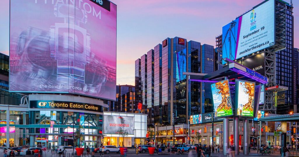
2. Dundas Square:
2.1 History-
Yonge–Dundas Square, or Dundas Square is a public square at the southeast corner of the intersection of Yonge Street and Dundas Street East in Downtown Toronto, Ontario, Canada. Designed by Brown and Storey Architects, the square was conceived in 1997 as part of revitalizing the intersection. Since its completion in 2002, the square has hosted many public events, performances and art displays, establishing itself as a prominent landmark in Toronto and one of the city’s prime tourist attractions.
2.2 How to go there?
BY PUBLIC TRANSIT (TTC): Take Line 1 Yonge-University subway northbound or southbound (depending on where you are) and exit at Dundas Station.
For hours of operation and fare info, and maps call the TTC at (416) 393-4636 or visit www.ttc.ca
BY CAR: Yonge Street and Dundas Street E. are the major Toronto streets that intersect in Yonge-Dundas Square. The address is: 1 Dundas St E, Toronto, ON.
PARKING: Yonge-Dundas Square is constructed on top of a 250-space parking facility operated by the Toronto Parking Authority. The entrance to the parking garage is located at the corner of Victoria Street and Dundas Streets, and is also accessible by elevator on the north side of the Square.
To know about the events in Dundas Square, Toronto. Please visit this Calendar.
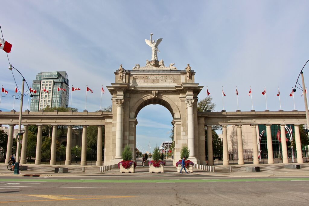
3. Princes’ Gate:
3.1 History-
The Princes’ Gates is a Triumphal Architecture and a monumental gateway at Exhibition Place in Toronto, Ontario, Canada. Made out of cement and stone, the triumphal arch is flanked by colonnades on both of its sides, with curved pylons at both ends. The 350-foot-long (110 m) structure serves as the eastern gateway to the Canadian National Exhibition, an annual agricultural and provincial fair held at Exhibition Place.
The Princes’ Gates was initially conceived in the 1920s, forming part of a larger redevelopment effort of the eastern portions of Exhibition Place. Work began on Princes’ Gates in April 1927, and was completed several months later in August. The structure was initially planned to be named the Diamond Jubilee of Confederation Gates, with its opening coinciding with the 60th anniversary of Canadian Confederation.
3.2 How to go there?
Wondering how to get to 11 Princes’ Boulevard in Toronto, Canada?
Looking for the nearest stop or station to 11 Princes’ Boulevard?
Check out this list of stops closest to your destination:
East Liberty St at Pirandello St; Princes’ Blvd at Strachan Ave; Princes’ Gates Loop at Canada Blvd – Cne East Entrance; Fleet St at Strachan Ave; Manitoba Dr at Strachan Ave West Side; Strachan Ave at East Liberty St.
Bus:307
329
Train: LW
Subway:1
11 Princes’ Boulevard Address: 11 Princes’ Blvd, Toronto, ON M6K 3C3, Canada street in Toronto
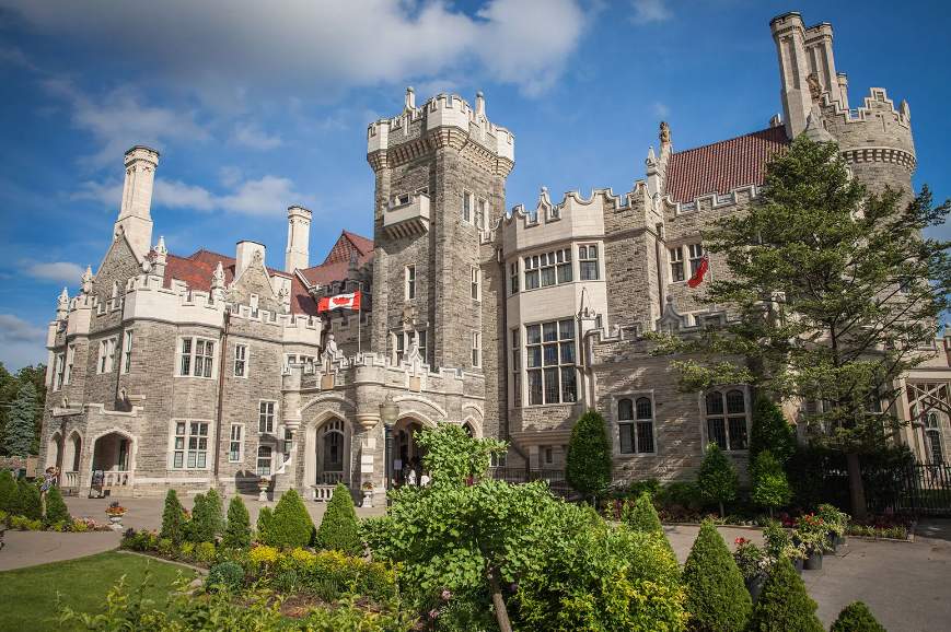
4. Casa Loma:
4.1 History-
Step back in time at Casa Loma, Toronto’s urban castle. Completed in 1914, Casa Loma has a fascinating backstory and offers a unique view into Canada’s past as well.
Enjoy several in-house museums, decadently preserved rooms, several dining options and special events. Spend a day exploring the castle’s three floors, the stables outside and the manicured gardens surround the estate.
Explore at your own pace or take a tour, making sure to stop at each of the museum exhibits. Discover secret passageways inside and take in the unmatched view of the Toronto skyline and the estate’s five acres of gardens.
Visit Casa Loma Website to plan your trip
4.2 How to go there?
Castle Loma is located at 1 Austin Terrace, Toronto, Ontario M5R 1X8, at the corner of Spadina Road and Davenport Road.
Public Transportation:
There are four ways to get to Casa Loma by the Toronto Transit Commission (TTC):
Get off at Dupont station, which is two stops north of St. George station on the Spadina-University line. When you exit the station, walk two blocks north on Spadina Avenue. To get to Casa Loma you can climb the Baldwin Steps at Spadina Avenue. and Davenport Road; there are 110 steps. You can also walk up the hill on the west side of the castle, though this is a rather steep climb which can be difficult on hot days.
Take the Davenport 127 bus from Spadina Station to Davenport & Spadina. You can get off the bus here and climb the Baldwin steps or stay on the bus for one more stop to Davenport and Walmer and walk up the hill on the west side of the castle.
Get off at St. Clair West station on the Spadina-University line. When you exit the station, walk east on St. Clair to Spadina, and turn right (south). Casa Loma is about a 15 minute walk along Spadina Ave.
Get off at St. Clair West station on the Yonge line. You can take a 5 minute ride on the St. Clair streetcar going west to Spadina Road. Walk approximately 10 minutes south on Spadina Road to Casa Loma.
4.3 Getting your Casa Loma tickets
General Admission ticket Cost-
Adult (18-64 yrs) = $ 40 ($36.55+ HST)
Seniors( 65+ yrs) = $ 35 ($32.12 + HST)
Youth (14-17 yrs) = $ 35 ($32.12 + HST)
Children (4-13 yrs) = $25($22.15+ HST)
Children under 3 are admitted free, when accompanied by a ticketed adult.
Entrance to Sir Henry Pellatt documentary and complimentary mobile audio guide app are included with General Admission. Audio Guide devices can be rented from the Gift Shop.
CityPASS tickets allow you to join the expedited line for entry to Casa Loma. Just present your CityPASS ticket at the box office or the Front Reception Desk.
To buy tickets of Casa Loma visit here
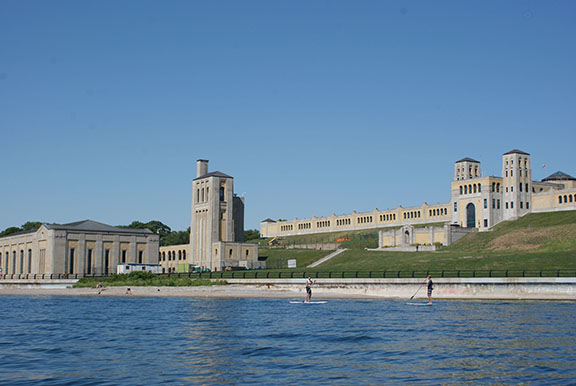
5. R. C. Harris Water Treatment Plant:
5.1 History
The R. C. Harris Water Treatment Plant in Toronto, Ontario, Canada, is both a crucial piece of infrastructure and an architecturally acclaimed historic building named after the longtime commissioner of Toronto’s public works Roland Caldwell Harris.
Commanding heavenly views of the lakefront from a priceless slab of real estate, the elegantly proportioned RC Harris Water Treatment Plant is an art-deco masterpiece that has appeared in countless movies and TV shows. Originally disparagingly dubbed the ‘Palace of Purification’ due to hefty construction costs during the Great Depression, the fully operational plant is rarely open to the public – try during doors open– but it makes a great photographic subject.
If the thought of visiting a water treatment plant doesn’t thrill, consider the dramatic location of this imposing 1930s Art Deco building: it sits on a terraced landscape with an unimpeded view of the vastness of Lake Ontario. Visitors feel like they’re on a movie set, even though the hum inside is real equipment cleaning 950 million liters of water per day. The interior is infrequently opened to visitors. The RC Harris Water Treatment Plant is a short walk, bike or rollerblade from The Beach (or, more contentiously, The Beaches), the city’s finest stretch of sand and one of the best neighborhoods to eat ice cream in.
5.2 How to go there?
R.C. Harris Water Treatment Plant is located at 2701 Queen St E, Scarborough, ON M4E 1H4
To visit the R.C. Harris Water Treatment Plant in Toronto using public transportation, you have several options:
By Bus: Take bus 322 or 324. Get off at 127 Victoria Park Ave (13-minute walk), Kingston Rd at Blantyre Ave (15-minute walk), or Kingston Rd at Victoria Park Ave (15-minute walk).
By Train: Use the LE train line.Travel times vary; for example, from Le Germain Hotel Toronto Mercer, it takes about 63 minutes.
By Subway: Take Line 2. For instance, from Casa Loma, it takes around 71 minutes.
By Streetcar: Take the streetcar to Queen St East at Beech Ave, which is a 10-minute walk from the plant.
Travel times differ based on your starting point. For example, from GoodLife Fitness Centres, it’s a 37-minute trip, while from the Rogers Centre, it takes about 89 minutes. Public transit offers convenient routes to the R.C. Harris Water Treatment Plant.
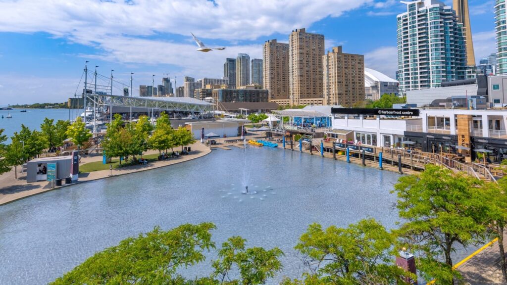
6. Harbourfront Center:
6.1 History
Harbourfront Centre is a cultural organization on the waterfront of Toronto, Ontario, Canada, situated at 235 Queens Quay West. Established as a crown corporation in 1972 [dubious – discussed] by the Government of Canada to create a waterfront park, it became a non-profit organization in 1991. Funding comes from corporate sponsors, government grants, individual donors and entrepreneurial activities. Harbourfront Centre has a seating capacity of 2,000.
Harbourfront Centre, on Toronto’s waterfront, is an innovative not-for-profit cultural organization that creates events and activities of excellence that enliven, educate and entertain a diverse public.
To know more about Harbourfront Center visit here
6.2 How to go there?
Harbourfront Centre is located at 235 Queens Quay W, Toronto, ON M5J 2G8
To visit Harbourfront Centre in Toronto using public transportation, here are your options:
By Bus: Take bus 320. For example, from the Canadian Tire Home Office, it takes 32 minutes.
By Train: Use the MI or UP train lines. From the TTC 192 Airport Rocket, it takes 41 minutes.
By Subway: Take Line 1. From the Canadian Tire Home Office, it takes 29 minutes.
By Streetcar: Get off at Queens Quay West at Harbourfront Centre, a 2-minute walk away.
Public transit offers easy and convenient routes to Harbourfront Centre, making it accessible from various locations in the city.
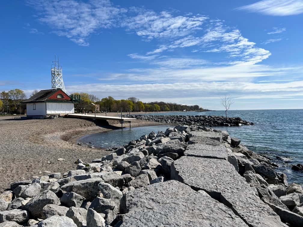
7. Woodbine Beach
7.1 History-
Toronto, a bustling metropolis known for its skyscrapers and vibrant city life, also offers serene escapes like Woodbine Beach. Located in the east end of the city along the shores of Lake Ontario, Woodbine Beach is a popular destination for locals and tourists alike, providing a perfect blend of natural beauty, recreational activities, and historical significance.
Woodbine Beach has a rich history dating back to the early 20th century. Originally a site for local fishermen and swimmers, the area began to develop as a recreational hub in the 1900s. The beach is named after the Woodbine Race Course, which was situated nearby and contributed to the area’s popularity.
To know more about Woodbine Beach click here
7.2 How to go there?
Woodbine Beach is located at 1675 Lake Shore Blvd E, Toronto, ON M4L 3W6
Reaching Woodbine Beach is straightforward with Toronto’s extensive public transportation system.
By Subway and Bus: Take Line 2 (Bloor-Danforth) to Woodbine Station.From Woodbine Station, transfer to bus 92, which will take you directly to the beach.
By Streetcar: Take the 501 Queen streetcar eastbound.Get off at the Woodbine Avenue stop and walk south to the beach.
By Car: If driving, head east on Lake Shore Boulevard East. Ample parking is available near the beach, though it can fill up quickly on sunny days.
By Bike: For those who enjoy cycling, the Martin Goodman Trail provides a scenic route along the waterfront straight to Woodbine Beach.
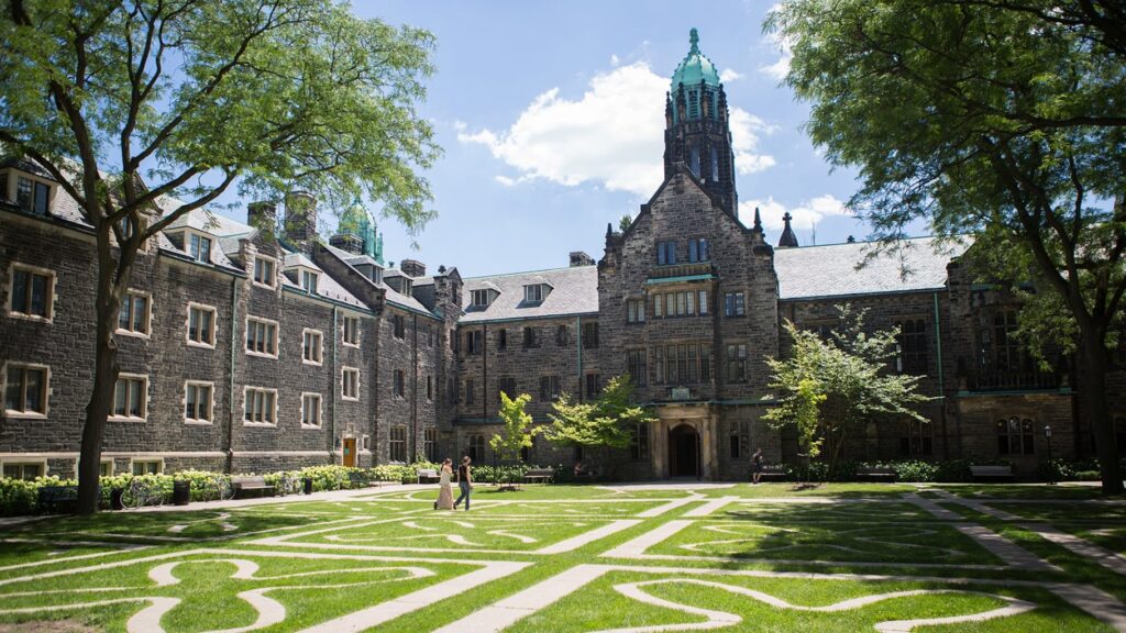
8. University of Toronto
8.1 History
The University of Toronto (UToronto) is a public research university in Toronto, Ontario, Canada, located on the grounds that surround Queen’s Park. It was founded by royal charter in 1827 as King’s College, the first institution of higher learning in Upper Canada. Originally controlled by the Church of England, the university assumed its present name in 1850 upon becoming a secular institution. As a collegiate university, it comprises 11 colleges each with substantial autonomy on financial and institutional affairs and significant differences in character and history. The university maintains three campuses, the oldest of which is St. George, located in downtown Toronto. The other two satellite campuses are located in Scarborough and Mississauga.
8.2 Exploring the University of Toronto
Visitors to the University of Toronto can immerse themselves in a plethora of enriching experiences:
Campus Tours: Guided tours are available for those interested in learning about the university’s history, architecture, and academic programs.
Museums and Galleries: The university houses several museums and galleries, including the Royal Ontario Museum and the Art Museum at the University of Toronto, showcasing diverse collections of art, artifacts, and historical treasures.
Public Lectures and Events: The university regularly hosts public lectures, seminars, and cultural events that are open to visitors, providing opportunities to engage with leading scholars, artists, and thought leaders.
Green Spaces: Take a leisurely stroll through the picturesque campus grounds, dotted with lush greenery, tranquil gardens, and charming courtyards.
Cafés and Dining Halls: Enjoy a cup of coffee or a meal at one of the campus cafés or dining halls, frequented by students and faculty alike.
8.3 How to Get to the University of Toronto
Navigating your way to the University of Toronto is convenient, thanks to Toronto’s efficient public transportation system:
By Subway: Take Line 1 (Yonge-University) and exit at either St. George or Museum station, both of which provide easy access to the university’s St. George campus.
By Streetcar: Several streetcar routes, including the 510 Spadina and 506 Carlton, stop near the university’s downtown campus.
By Bus: Numerous bus routes connect various parts of the city to the university’s campuses, making it easily accessible from all directions.
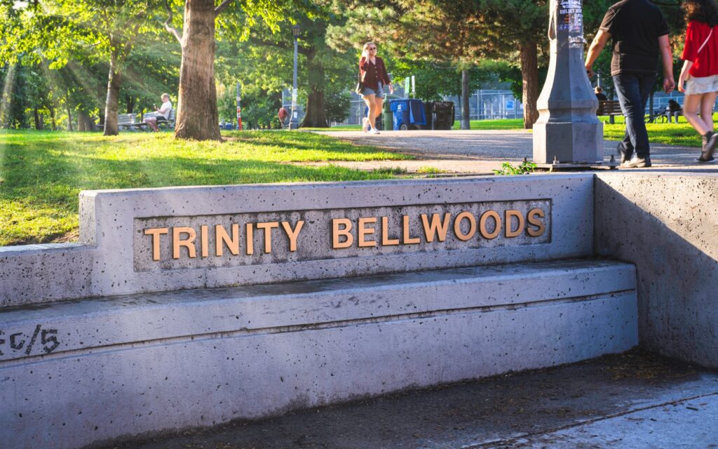
9. Trinity Bellwoods Park
9.1 History
Trinity Bellwoods Park has a storied past dating back to the early 19th century. Originally part of a land grant given to the Denison family in the 1790s, the area was eventually acquired by the city of Toronto in 1856 for use as a public park. Named after the nearby Trinity College, the park has since evolved into a cherished green space beloved by locals and visitors alike.
To know more about Trinity Bellwoods Park click here
9.2 How to go there
Trinity Bellwoods Park is located at 790 Queen St W, Toronto, ON M6J 1G3
Getting to Trinity Bellwoods Park is easy, thanks to Toronto’s extensive public transportation network:
By Subway: Take Line 2 (Bloor-Danforth) to Ossington Station or Line 1 (Yonge-University) to Queen Station, both of which are a short walk from the park.
By Streetcar: The 501 Queen and 504 King streetcars both pass by the park, providing convenient access from various parts of the city.
By Bus: Several bus routes, including the 63 Ossington and 29 Dufferin, stop near the park, making it easily accessible by public transit.